| Day
26 (Aug. 6th): BLUFF, UT to TUBA CITY, AZ |
 |
| <- PREVIOUS DAY | Predicted Dist. & Time: 142 mi. / 2:15 - Actual Dist. / Drive / Total Time: 174.3 mi. / 3:47 / 5:32 | NEXT DAY -> | |
|
Click n' Return:
|
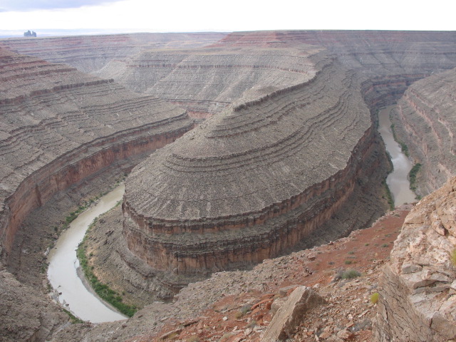
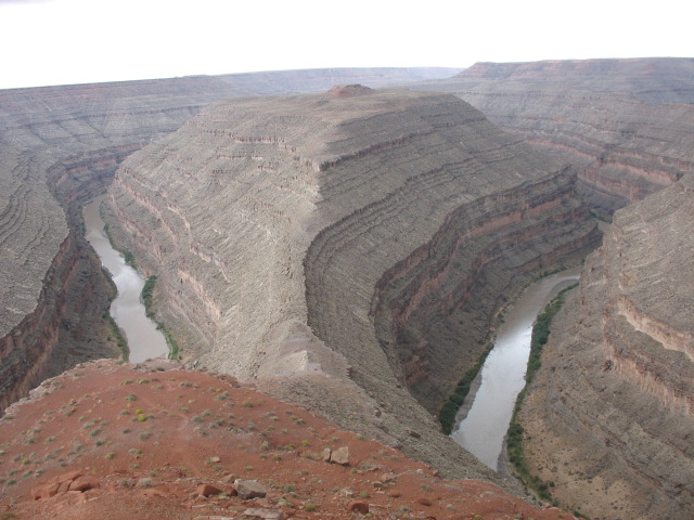
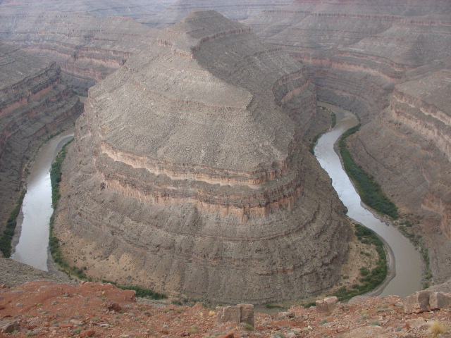
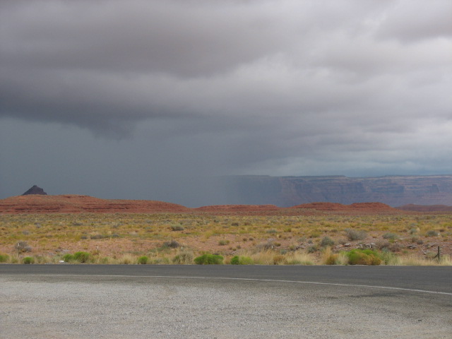
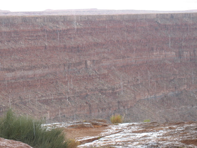
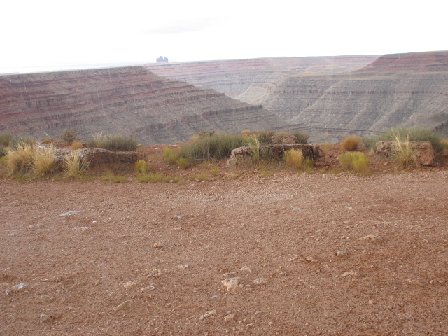
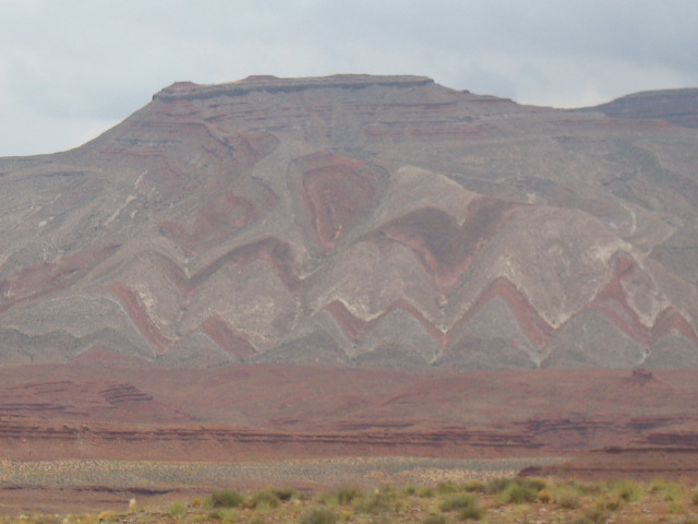
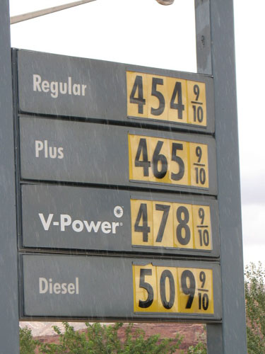
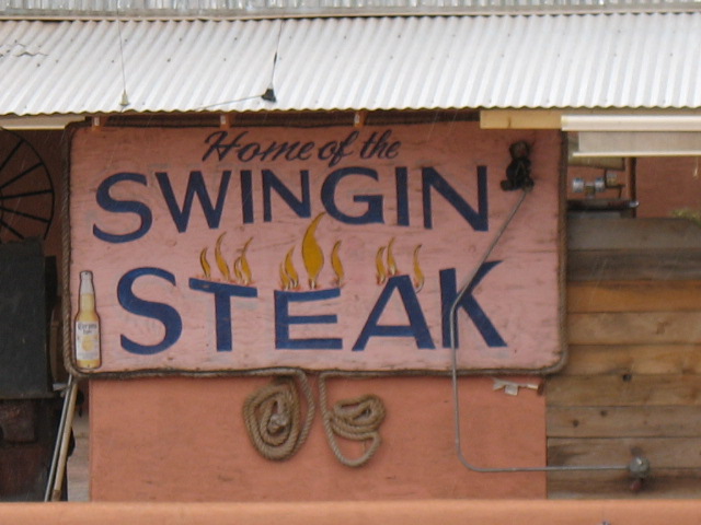
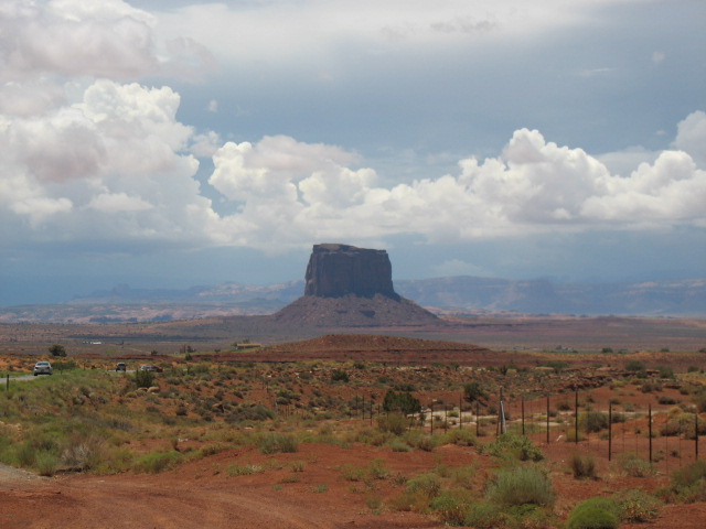
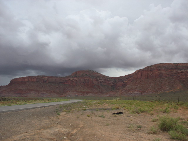
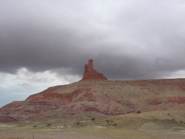
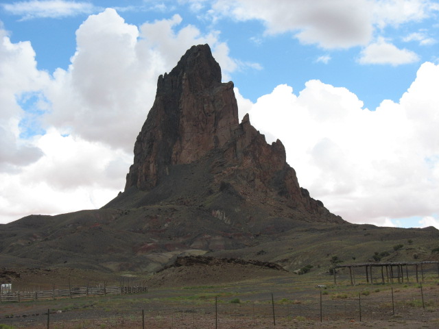
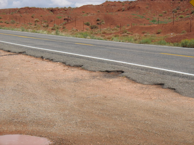
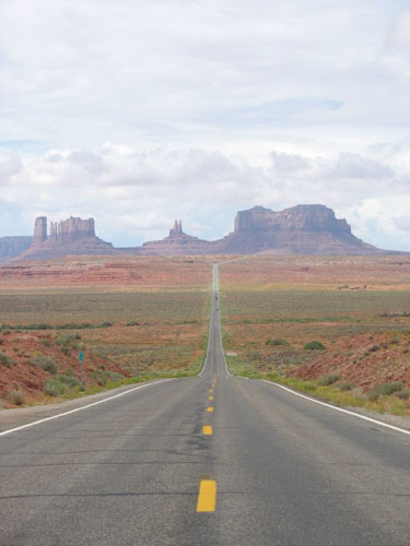
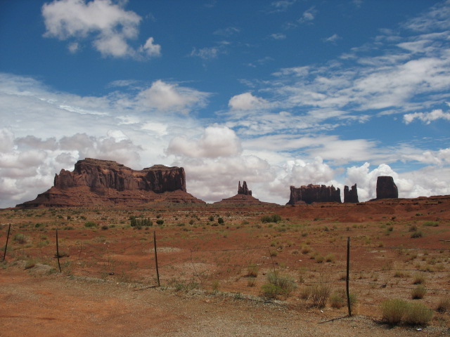
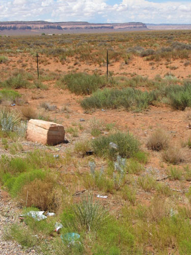
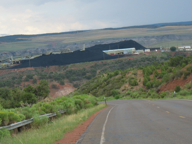
DAY TWENTY-SIX COMMENTARY Do they call Utah “The Mosquito State”? It seemed to me that a bunch of them were out much later into the night than I think I’ve ever seen them, and here they were back again in the early AM! On the other hand, perhaps this was a one-time trade-off, and one I suppose I’d gladly accept: despite the threatening clouds and lightning I saw all throughout the ride up here to Bluff last night, I don’t believe we saw even a single drop of rain, neither while I was setting up nor preparing dinner. We’ll take it! I couldn’t help but notice that two other sets of folks managed a much faster tent site departure than I did, but at least I knew the reason why -- they had four people dividing up the tear-down duties, whereas The Chief (tm) was, as always, doing it solo. Doing the same darned thing day in and day out has, in fact, allowed me to make some small discoveries and adjustments, a mere four weeks into the trip. To wit: I put my clear plastic storage sleeves on their sides within the box they reside, whereas I used to lay them flat atop one another; now I don’t have to go through all of them when the single item I need would otherwise be found in -- what else? -- the sleeve on the bottom. Neat! I also tried resting the big plastic envelope of paper keepsakes -- maps, pamphlets, receipts, etc. -- upright in the right-side saddlebag, and found that it would close far more easily with the full-face helmet in there than it did when laying on its end. Neat! Four weeks it took me to make these discoveries, people. Back on the road again! Not long after pulling out of the campground -- OK, maybe about sixty seconds -- I realized I had better put that rain gear on again, for it was out there waiting for me, directly in the path of the road. Throughout the day it was rain, sun, rain, sun; a real pain in the neck! It would be taxing enough to drive through the, ahem, “driving” rain -- and that’s exactly what it was -- and then it would be steamy and sweltering inside the rain gear when the warm sun emerged again. Probably the biggest annoyance was the impact on picture taking, for several reasons: first, while I usually kept the camera right inside the front of the tank bag for easy access, even while wearing riding gloves, that bag is not completely waterproof, so I usually elected to affix its rain cover when the nasty stuff loomed. The cover always seemed to resist being easily removed for access to the zippered flap below. Next, because I was wearing three-fingered rain gloves over my riding gloves, it was even more difficult to remove the rain cover, then unzip the bag, then turn on and operate the camera. So taking a picture became an ordeal involving not just finding a safe place to pull over, but also to remove the rain gloves, remove the tank bag rain cover, open the bag, and take the shot -- and then put it all back together. A decision to keep the camera in the sealable front pocket of my rain jacket similarly met with only limited success, as I could never seem to find the zipper pull with my gloves on, this time requiring me to either flip open the front of my helmet, or remove the rain gloves. And the rain gloves, while completely water-tight, suffered from a design flaw in which the Velcro wrist strap was too short to leave attached, while still fitting a gloved hand through, so I had to repeatedly feed the strap through its clasp each time I put them back on. Try slipping a Velcro strap through a tiny clasp, first with one hand, then with the other hand, but wearing two sets of gloves the second time around. OK, enough of that garbage -- just wanted to let you know what I’m out here doing for you people. Weather aside, I followed Rte. 163 west and came across the rock formation known as Mexican Hat, from which the nearby “town” takes its name. What’s interesting is that, certainly within our lifetimes, if a small tremor were to roll through this area, Mexican Hat (the rock, not the town) could be no more. Right nearby was the access road to Goosenecks State Park, so I dove in. What was at first most impressive about the Goosenecks -- where the San Juan River, flowing 1,000 feet beneath where I stood, had carved several 270-degree turns into the rock in a formation known as an "entrenched meander"-- was that the overlooks led right to the rim. This meant that anyone with a camera could take pictures of the same exact perspectives one might find on websites or professionally-produced documents. As such, and finding the carved canyons to be breathtaking, I certainly got into the act. Next, as yet another storm approached, what happened was that the rain fell gently, and the drops seemed almost to be individually illuminated by the sunlight trying to burst through the clouds from the opposite direction. It felt like you could pick out a rain drop and watch it fall all the way to the bottom of the canyon, almost in the manner that snowflakes flutter to the ground. The effect was mesmerizing and, because I still sported the rain gear and my full face helmet, I remained dry as I watched for minutes at a time, while others sought shelter inside their RV’s. Without even fiddling with shutter speeds on my camera, it was able to capture the drops as they slowly fell towards the river below. As thrilled as I was to have come here -- for which I must thank the National Geographic publication, “America’s Hidden Corners” -- I was then also struck with disappointment. Consider: had I come here late last night and set up camp in the darkness, I could not have known what vista awaited me in the morning, just yards away from where my tent would have been. How tremendous would that have been, to wake up to such a beautiful surprise? Finally hopping back on the bike, directly beyond the intersection back at Rte. 163 was an excellent example of some of the varied geological processes that have been going on out here for the past billion years or so -- all occurring in (or “to”?) one particular area. As you can see, towards the top of the picture the striations in the exposed rock follow a linear pattern, even through the sections which are not perfectly parallel to the ground. Then it seems as if the whole shebang simply tumbles and curves down to the ground. From afar they reminded of an Indian blanket, or perhaps the design on good ol’ Charlie Brown’s shirt! Slightly further ahead was the town of Mexican Hat itself, which I thought would be a cool place to dispatch a letter from the town “Post Office” inside the Shell station (featuring the highest priced gasoline I had yet seen). Alas, at the moment there was no full-service counter and, worried about the proper postage -- as my return address, technically accurate, was “The Chief (tm), USA -- I decided not to risk the letter getting lost. I was sure I’d hit another memorable Post Office somewhere, though I wish I had had time to try out the "Swingin' Steak". Funny thing about trying out an unknown brand of trail mix -- you never know if you’ll like the ratio of the ingredients within. Currently I was working with a bag which I wished had featured more nuts and fewer raisins. Even when it was not raining, I could see little rivulets roaring down their washes, apparently not having been fed in some time; it was easy to imagine how the face of the landscape could change as the infrequent, but frequently violent storms roared through. The scenery remained astounding; it took me just shy of two hours to cover the 40.6 mile stretch between Bluff and Monument Valley, which according to the GPS broke down to sixty-two minutes moving, and fifty-three minutes stopped. People, I wasn’t stopping when it was raining, I was stopping to take dozens and dozens of pictures! Often multiple ones of the same angle, but trying to play with the light; upon hopping back on the bike and riding 500 or so yards, the view might change enough that I would jump back off and snap a few more. All the while, remember, I had to be careful because the pulloffs were mere gravel, or dirt, and they had just recently been doused with bucketsful o’ rain, and the return to the pavement was rarely clean either. Here are a few renditions of the classic view of the main formation in Monument Valley, called “Mitten Rock”, I believe. It was worth taking multiple shots of the same perspective, hoping to capture it just right (including one from behind it). I’m not sure whether or not I did that, but I do believe I may have caught what could be the “money shot” of the entire trip? I don’t mean the best thing that I saw, or did, but the picture that kind of sums up the whole gig. In order to be a surprise, I didn’t even put a thumbnail of it on this page. BTW, you think it was easy to set this one up? In an early look at what was to become a trend, it seemed as if Europeans were pouring out of RV’s everywhere one looked. Certainly if a camper showed indications that it was a rental, you’d best be prepared to put your French to use, or your Italian, or Dutch, or Spanish, or German. There were folks who were visiting the US for the first time and those who had been here many, many years ago, but it seemed that all of them had major itineraries planned for themselves, covering many states and many thousands of miles across the beautiful southwest. And why shouldn’t they? In addition to the strength of the Euro relative to the dollar, something I had forgotten about (but that they reminded me of) was the typically far-longer vacation time they enjoyed compared to us poor Yanks. (Another aside: who would ever think to litter in a place of such unspoiled natural beauty?) Throughout the ride I had been flirting with the now-customary black, end-of-the-world storm clouds just off in the distance, and crossing over the roadway for ten minutes at a time here and there as well. I had decided to simply wear the raingear the entire time, rather than stop and change every fifteen minutes or whatever it would have been. Well, people, lemme tell ya, this strategy was soon “rewarded”, as it started to rain so hard, and the wind to blow so hard, that the droplets were coming from right to left at what had to have been a thirty degree angle. Pouring, pouring rain and sustained, serious wind from right to left. Should I have stopped? Of course. But to do what -- stand out there in the pouring rain? Negative. The Chief (tm) stoically continued on, at essentially the same exact pace as in the dry, except that I was leaning hard to the right against the wind, and then also skirting the right side of the road surface as the wind strengthened and began to blow the water out of the westbound lane and into the eastbound one. Had I been able to take a picture of this, I would have. I saw a sign pointing to the left for “Black Mesa”, which is where the old Hopi villages I had learned of (back in Knoxville and Fredericksburg) are located. I hadn’t known that one could reach them from up here -- I thought the trip required ducking down south, then east, from my destination of Tuba City, a route which was more out of the way and which I was less likely to embark upon in my possible quest to find the villager. Here, though, I figured I was ahead of schedule, and any change in the weather (fine for the moment) wouldn’t be any worse than what I had already been through, so I turned off. I passed a few coal mining operations and through a few drizzles, and could see the mesas in the distance when suddenly the pavement came to an end. The road continued as graded dirt, but I didn’t like my chances in the rain, let alone what washouts I may encounter up ahead. Just about to bail on the whole idea, I saw a guy sitting in a road grader near a coal plant and decided to chat him up. Turns out he is the gent in charge of grading the road, and as such as he was a great resource to talk to -- he advised, from first-hand knowledge, that it would be a bad idea indeed for me to try to continue on. At the same time, he also told me that the road down from Tuba City is paved the entire way, so if I chose to do that in the morning I would not be at the mercy of road conditions. Turns out his son is around college age and may be taking a look at Brandeis, in Waltham, MA, and I wish him success in that attempt should he decide to go for it. I also learned that the slurry pipe runs can go on for hundreds of miles, and that the water usage patterns by the coal mining operations has been very contentious, leading to difficulties amongst and between the Navajo, Hopi, and The Man. Eventually entering Tuba City from the east, we had a reversal of the usual routine -- I passed on paying $3.999 a gallon on the very edge of town, and instead caught it at $3.80 just two blocks later, PLUS enjoyed a trailer tire rotation next door for just $12! Somewhere along the line, in the rain, there was this. When I got to the hotel / campsite, I inquired about the availability of a room instead, as I figured that at least one of those mini-storms would eventually find a way to dump buckets of water all over my tent. I was told that there were no rooms available whatsoever -- and, not to be rude, I joked that this came as a surprise seeing how many parking spots were open in the lot. To which the gal behind the desk said that there’d be two tour buses coming in any minute, and as such I should get my arse to the restaurant next door before the buses arrived and the joint became packed. This I did, and I was rewarded with a yummy native-style frybread dinner. When I got back to the campsite, I noticed that the Ant Invasion had begun -- perhaps I had erected the tent atop an ant hill, but whatever the reason, the little critters were crawling all over the damned thing. With little else in the way of a solution, I swatted each one to the ground individually, then sprayed mosquito repellent all away around the bottom of the tent. Seemed to keep the bastards from crawling back onto it… BTW the front desk hadn’t been kidding about there being no rooms around; as I worked feverishly deep into the night to provide you with these updates, there was a steady stream of folks coming in late, past 11 PM and the like, also axing about rooms. The desk knew that the whole town was booked, and so was recommending that travelers -- who’d had more than enough of the open road -- get right back on it and head to Flagstaff, AZ, some eighty miles away. Now, when I called weeks ago they had told me I wouldn’t even need to reserve a tent site because they never fill up, but here I suppose I was glad I managed to snag one site at all -- they might have been all gone had I not checked in when I did… and they would have had a nightmare on their hands... Two random funnies -- first, I noticed that the bike’s horn was working only intermittently (before/during/after the downpours?) I know for a fact that it worked right after one particular rainstorm, but then did NOT work when I wanted to beep at some kids waving to me from upon bicycles in Cortez. Then, somehow, it was working again later on. Signs of bad news, electrically-speaking, to come? Let’s hope not, for those can be tricky to track down (even for experts, of which group I definitely am not one). Second, somewhere along the line I looked at myself in a mirror and noticed that my goatee has far more gray hair in it than the rest of my head -- and the goatee exists in the first place because I haven’t shaven in three weeks, because I was scared to carry shaving cream, because I figured it’d blow up from the heat generated inside the trailer through TX and the Southwest! In the “Right Idea, Wrong Execution” department, I sent an emergency text message to a truly gray-haired fellow stating, simply, “SEND BRYLCREEM”. Well, I texted the right guy, at least, because he set me straight -- what I should have written was "Hair Club For Men". Either way, still no Brylcreem. |
|
|
|
|
|||